Hudbay Announces Significant New Discovery at its Copper World Properties Adjacent to Rosemont
- Drill hole #035A intersected 500 feet of 0.82% copper starting at surface
- Drill hole #012 intersected 246 feet of 0.70% copper starting at surface
- Drill hole #011 intersected 440 feet of 1.38% copper
- All new intersections are on Hudbay’s wholly-owned private land
/EIN News/ -- TORONTO, March 29, 2021 (GLOBE NEWSWIRE) -- Hudbay Minerals Inc. (“Hudbay” or the “company”) (TSX, NYSE: HBM) today announced the intersection of high-grade copper sulphide and oxide mineralization at shallow depth on its wholly-owned patented mining claims located within seven kilometres of its Rosemont copper project in Arizona. The drill program was initiated in 2020 to confirm historical drilling in this past-producing copper region formerly known as Helvetia. After receiving encouraging initial results, the company launched a larger drill program in early 2021 and has since doubled the number of drill rigs at site to six to further test the four known deposits at Copper World and the potential for additional mineralization.
“This new discovery on our private land in Arizona demonstrates our team’s strong expertise in exploration,” said Peter Kukielski, Hudbay’s President and Chief Executive Officer. “They saw an opportunity to consolidate mineralization in the region and we are excited to continue to explore Copper World while remaining committed to advancing Rosemont through the appeals process.”
Regional View of Copper World
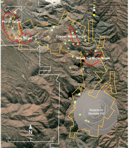
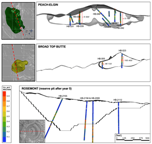
The Copper World deposits are located adjacent to the Rosemont deposit as shown in the plan view in Figure 1. To date, four deposits have been identified with a combined strike length of over five kilometres with opportunities to discover additional mineralization between the deposits. The mineralization occurs at shallower depths than at Rosemont as shown in Figure 2.
“We are very encouraged by the results from the recent drill program at Copper World, where we have intersected copper mineralization that contains higher grades closer to surface than at Rosemont,” said Cashel Meagher, Hudbay’s Senior Vice President and Chief Operating Officer. “Copper World has the potential to host at least four economic deposits with a relatively low strip ratio and may prove to be a viable open-pit operation that is either separate from or additive to our Rosemont project.”
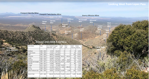
The Copper World region has a rich history of mining from 1874 to 1969, during which time more than 20 small underground mines produced a total of approximately 440,000 tons at an average copper grade of 4.42%. Figure 3 illustrates the historical mining activity in the region. This is the first time the region has been explored as a zone of continuous mineralization.
A three-dimensional visualization of the Copper World drill results can be found at the link noted below. This visual shows the location of the Copper World targets, the historical mine sites in the area, the historical drilling coverage (the results of which are under review and will be reported once the data is validated by Hudbay in accordance with NI 43-101), as well as drill hole intercepts from Hudbay’s 2020 drill campaign.
https://vrify.com/embed/decks/Hudbay-PR-Deck-03-29
Copper World 2020 Drill Program
Hudbay’s 2020 exploration work began by compiling and validating all historical data on its private land claims and refining the geological model. This initial review included the discovery of records of historical drilling results for which assay results cannot be disclosed until the data is validated by Hudbay in accordance with NI 43-101. However, this review suggested the potential for both copper sulphide and oxide mineralization in skarns and porphyries near surface in several areas. In September 2020, the company initiated a 15,000-foot drill program which was quickly expanded to a 40,000-foot drill program after early encouraging intersections of mineralization. During this initial program, three drill rigs focused on testing the Broad Top Butte, Copper World, Peach and Elgin targets (referred to collectively as the “Copper World deposits”).
Hudbay has recently received the assay results from the 2020 drill program and the results have exceeded Hudbay’s expectations. The program confirmed the discovery of four new deposits based on significant volumes of high-grade copper sulphide and oxide mineralization starting, in most cases, near surface or at shallow depth.
Broad Top Butte Targets
- Drill hole #011 intersected 440 feet of 1.38% copper, including 70 feet of 4.2% copper
- Drill hole #012 intersected 246 feet of 0.70% copper starting at surface
- Drill hole #023 intersected 300 feet of 0.91% copper
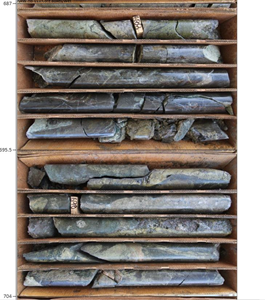
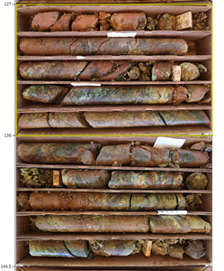
The 2020 drilling at Broad Top Butte confirmed the occurrence of significant shallow copper oxide and sulphide mineralization. Sulphide mineralization was found in a quartz-monzonite porphyry intrusive and in surrounding skarns at the contact with carbonate units in a similar geological setting as Rosemont. Drill hole #011 intersected a very strong mineralized zone of 440 feet of 1.38% copper starting at 365 feet from surface, including 70 feet of 4.2% copper in a massive sulphide zone with chalcopyrite and bornite in skarn (please refer to Figure 4 for a visual of the drill core). This high-grade sulphide mineralization appears to be similar in copper content to the historical production from the nearby King Exile mine located approximately 200 feet to the north of this drill hole intersection. King Exile mine was discovered in 1899 and was in production until 1959. Copper oxide mineralization was found in the upper portion of the mineralized zones both in porphyry and skarns. The drilling also intersected significant mineralization in areas with no historical drilling along a major regional structure, known as the backbone fault. This domain consists of quartzite and other sedimentary units located along a north trending steep dipping fault zone that hosts significant oxide mineralization that can be mapped on surface almost as a continuum from Broad Top Butte to the Rosemont deposit. Notably, drill hole #012 intersected 246 feet of 0.70% copper from surface. The samples included in this mineralized interval were also tested for their solubility in sulfuric acid to measure the copper content in oxides. The average grade of soluble copper in sulfuric acid (CuSS) is 0.53% indicating that approximately 75% of the copper is contained in oxides and easily recoverable by a proven and low-cost leaching technology. Please refer to Figure 5 for a visual of the drill core from hole #012.
Peach and Elgin Targets
- Drill hole #035A intersected 500 feet of 0.82% copper starting at surface
- Drill hole #037 intersected 600 feet of 0.40% copper starting at surface
- Drill hole #048 intersected 280 feet of 0.46% copper starting at surface
- Drill hole #051 intersected 140 feet of 1.01% copper starting at surface
- Drill hole #062 intersected 300 feet of 0.64% copper starting at surface
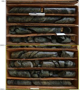
All of the 2020 drill holes at the Peach target included at least one significant mineralized intercept. Many included high-grade thick intercepts starting at or very near surface, with significant copper oxide in the upper portion of the profile. Drill hole #035A intersected 500 feet of 0.82% copper from surface with 40% of the copper in oxides (please refer to Figure 6 for a visual of this intersection). Similarly, hole #062 intersected 300 feet of 0.64% copper from surface with 40% of the copper in oxides.
At the Elgin target, shallow mineralization also starts at surface in most cases. Drill hole #051 intersected 140 feet of 1.01% copper from surface and hole #048 intersected 280 feet of 0.46% copper from surface. The Elgin deposit remains open to the south and to the east where another porphyry intrusive similar in geometry and nature as those identified at Rosemont and Broad Top Butte appears to be the main controlling feature associated with the occurrence of copper mineralization.
Next Steps
Given the very positive results from last year’s drill program, Hudbay initiated a second phase of exploration drilling in 2021 with a 70,000 foot follow-up drill program and has doubled the number of drill rigs operating at site to six. The 2021 program will focus on developing an understanding of the full extent of the mineralization at the Copper World deposits and potentially defining initial mineral resource estimates. Mineralogical studies and metallurgical testing have also been initiated and are expected to continue in the coming months. Geophysical surveys are underway to assist in generating further targets in this prolific region. Hudbay has a current exploration budget of approximately $10 million for its Arizona properties in 2021 which is likely to increase with further exploration success. Hudbay will review the results from its 2021 exploration program to determine the next steps for its Copper World properties and the potential synergies with Rosemont.
Copper World Detailed Assay Results
Broad Top Butte - Copper World
| Hole ID# |
From (ft) |
To (ft) |
Length (ft) |
Length (m) |
Cu1 (%) |
Ag1 (g/t) |
CuSS1,2 (%) |
Mo1 (g/t) |
Location |
| 002 | No significant mineralization | Broad Top | |||||||
| 005 | 15 | 48 | 33 | 10 | 0.75 | 19.2 | 0.53 | 121 | Broad Top |
| 005 | 48 | 133 | 85 | 26 | 1.43 | 8.7 | 0.05 | 206 | Broad Top |
| 006 | 0 | 340 | 340 | 104 | 0.43 | 3.0 | pending | 173 | Broad Top |
| 007 | 0 | 121 | 121 | 37 | 0.19 | 1.2 | 0.11 | 13 | Broad Top |
| 007 | 121 | 415 | 294 | 90 | 0.52 | 2.8 | 0.06 | 198 | Broad Top |
| 008 | No significant mineralization | Broad Top | |||||||
| 009 | No significant mineralization | Broad Top | |||||||
| 010 | 0 | 180 | 180 | 55 | 0.20 | 1.5 | 0.13 | 83 | Broad Top |
| 011 | 365 | 805 | 440 | 134 | 1.38 | 6.2 | 0.04 | 33 | Broad Top |
| 014 | No significant mineralization | Broad Top | |||||||
| 015 | 0 | 290 | 290 | 88 | 0.28 | 1.2 | 0.16 | 105 | Broad Top |
| 016 | 0 | 280 | 280 | 85 | 0.71 | 3.7 | 0.29 | 149 | Broad Top |
| 017 | 55 | 425 | 370 | 113 | 0.30 | 1.1 | 0.22 | 151 | Broad Top |
| 018 | 0 | 524 | 524 | 160 | 0.30 | 2.3 | 0.01 | 97 | Broad Top |
| 019 | 0 | 675 | 675 | 206 | 0.44 | 1.7 | 0.12 | 190 | Broad Top |
| 020 | 0 | 357 | 357 | 109 | 0.59 | 3.6 | 0.23 | 161 | Broad Top |
| 023 | 100 | 400 | 300 | 91 | 0.91 | 2.7 | 0.48 | 196 | Broad Top |
| 024A | 130 | 500 | 370 | 113 | 0.33 | 1.1 | 0.25 | 184 | Broad Top |
| 027 | 310 | 450 | 140 | 43 | 0.39 | 2.4 | 0.10 | 64 | Broad Top |
| 032 | No significant mineralization | Broad Top | |||||||
| 012 | 0 | 246 | 246 | 75 | 0.70 | 3.3 | 0.53 | 42 | Broad Top |
| 013 | 0 | 60 | 60 | 18 | 0.37 | 1.4 | 0.29 | 15 | Broad Top |
| 013 | 190 | 335 | 145 | 44 | 0.38 | 2.2 | 0.17 | 50 | Broad Top |
| 034 | 80 | 195 | 115 | 35 | 0.67 | 4.0 | 0.17 | 53 | Broad Top |
| 001 | No significant mineralization | Copper World | |||||||
| 003 | 6 | 217 | 211 | 64 | 0.38 | 1.4 | 0.04 | 333 | Copper World |
| 004 | 26 | 122 | 96 | 29 | 0.30 | 3.9 | 0.20 | 28 | Copper World |
Note: Assay results are length-weighted because no specific gravity data is available. At this early stage of exploration, Hudbay does not have sufficient knowledge of the geometry of the mineralization to estimate true width.
- All copper, silver and molybdenum values are uncut.
- CuSS shows the average grade of soluble copper in sulfuric acid.
Peach
|
Hole ID# |
From (ft) |
To (ft) |
Length (ft) |
Length (m) |
Cu1 (%) |
Ag1 (g/t) |
CuSS1,2 (%) |
Mo1 (g/t) |
| 021 | 0 | 250 | 250 | 76 | 0.31 | 6.7 | 0.23 | 36 |
| 022 | 0 | 300 | 300 | 91 | 0.32 | 2.0 | 0.14 | 29 |
| 025 | 0 | 150 | 150 | 46 | 0.34 | 2.4 | 0.24 | 119 |
| 025 | 320 | 393 | 73 | 22 | 0.39 | 1.2 | 0.19 | 102 |
| 026 | 0 | 390 | 390 | 119 | 0.35 | 3.2 | 0.21 | 228 |
| 029 | 0 | 370 | 370 | 113 | 0.36 | 2.9 | 0.27 | 15 |
| 031 | 0 | 335 | 335 | 102 | 0.50 | 3.1 | 0.21 | 42 |
| 035A | 0 | 500 | 500 | 152 | 0.82 | 4.3 | 0.33 | 53 |
| 037 | 0 | 600 | 600 | 183 | 0.40 | 2.7 | 0.13 | 60 |
| 039 | 0 | 460 | 460 | 140 | 0.44 | 2.9 | 0.19 | 77 |
| 041 | 260 | 440 | 180 | 55 | 0.29 | 3.7 | 0.02 | 112 |
| 042 | 0 | 160 | 160 | 49 | 0.42 | 4.4 | 0.28 | 63 |
| 045 | 180 | 610 | 430 | 131 | 0.32 | 3.2 | 0.04 | 96 |
| 046 | 0 | 220 | 220 | 67 | 0.37 | 4.8 | 0.27 | 78 |
| 046 | 390 | 490 | 100 | 31 | 0.30 | 4.5 | 0.18 | 54 |
| 046 | 545 | 740 | 195 | 59 | 0.29 | 2.6 | 0.03 | 78 |
| 050B | 0 | 610 | 610 | 186 | 0.37 | 2.9 | 0.24 | 26 |
| 054 | 0 | 280 | 280 | 85 | 0.56 | 3.0 | 0.42 | 32 |
| 057 | 0 | 415 | 415 | 126 | 0.36 | 3.6 | 0.24 | 48 |
| 058 | 0 | 445 | 445 | 136 | 0.52 | 3.6 | 0.17 | 56 |
| 062 | 0 | 300 | 300 | 91 | 0.64 | 6.0 | 0.25 | 87 |
| 063 | 0 | 327 | 327 | 100 | 0.24 | 3.5 | pending | 59 |
| 065 | 0 | 188 | 188 | 57 | 0.56 | 4.3 | 0.27 | 84 |
Note: Assay results are length-weighted because no specific gravity data is available. At this early stage of exploration, Hudbay does not have sufficient knowledge of the geometry of the mineralization to estimate true width.
- All copper, silver and molybdenum values are uncut.
- CuSS shows the average grade of soluble copper in sulfuric acid.
Elgin
|
Hole ID# |
From (ft) |
To (ft) |
Length (ft) |
Length (m) |
Cu1 (%) |
Ag1 (g/t) |
CuSS1,2 (%) |
Mo1 (g/t) |
| 028 | No significant mineralization | |||||||
| 030 | 100 | 230 | 130 | 40 | 0.65 | 2.9 | 0.10 | 72 |
| 033 | No significant mineralization | |||||||
| 036 | No significant mineralization | |||||||
| 038 | No significant mineralization | |||||||
| 040 | 0 | 180 | 180 | 55 | 0.25 | 5.2 | 0.05 | 127 |
| 043 | No significant mineralization | |||||||
| 044 | No significant mineralization | |||||||
| 047 | No significant mineralization | |||||||
| 048 | 0 | 280 | 280 | 85 | 0.46 | 2.8 | 0.03 | 189 |
| 049 | 0 | 130 | 130 | 40 | 0.44 | 2.7 | 0.08 | 186 |
| 051 | 0 | 140 | 140 | 43 | 1.01 | 4.5 | 0.40 | 214 |
| 052 | 0 | 35 | 35 | 11 | 0.81 | 4.7 | 0.63 | 36 |
| 053 | 0 | 280 | 280 | 85 | 0.71 | 8.2 | 0.21 | 129 |
| 055 | 0 | 100 | 100 | 30 | 0.88 | 9.2 | 0.34 | 64 |
| 056 | No significant mineralization | |||||||
| 059 | 40 | 144 | 104 | 32 | 0.39 | 2.5 | 0.15 | 129 |
| 060 | 15 | 87 | 72 | 22 | 0.27 | 2.3 | 0.12 | 44 |
| 061 | No significant mineralization | |||||||
| 064 | 75 | 185 | 110 | 34 | 0.50 | 3.5 |
0.05 | 99 |
| 066 | 0 | 88 | 88 | 27 | 0.35 | 3.5 | 0.10 | 98 |
Note: Assay results are length-weighted because no specific gravity data is available. At this early stage of exploration, Hudbay does not have sufficient knowledge of the geometry of the mineralization to estimate true width.
- All copper, silver and molybdenum values are uncut.
- CuSS shows the average grade of soluble copper in sulfuric acid.
Qualified Person and NI 43-101
The scientific and technical information contained in or incorporated by reference into this news release has been prepared under the supervision of Olivier Tavchandjian, P. Geo., Hudbay’s Vice President, Exploration and Geology. Mr. Tavchandjian is a “Qualified Person” for purposes of National Instrument 43-101 — Standards of Disclosure for Mineral Projects (“NI 43-101”).
Mr. Tavchandjian has verified the exploration data disclosed in this news release, including sampling, analytical, and test data underlying the information or opinions expressed herein. The data verification and quality assurance / quality control (QA/QC) measures that were used as part of the Copper World drill program are summarized below:
- Drill core was removed from the core tube by drilling contractors and placed in labelled core boxes. Core was logged by geologist, photographed, measured for conductivity, and tagged with sample tags. Core was cut in half and placed in labeled sample bags with the sample tags and transported to the sample preparation lab of Bureau Veritas in Reno, Nevada by courier in locked trucks.
- Samples were prepared and assayed following standard analytical protocols at the Bureau Veritas Mineral Laboratories in Reno (NV) and Vancouver (BC). Samples were dried, crushed to 70% -passing 2mm (10 mesh), then riffle split and pulverized until 85% passing 75μm (-200 mesh). Analyses were carried using a combination of Inductively Coupled Plasma Mass Spectrometry (ICP-MS) and Inductively Coupled Plasma Emission Spectroscopy (ICP-ES), following multi acid digestion (Method MA200) to achieve near total dissolution. Gold was analyzed by fire assay with AAS finish (Method FA430). Samples with concentration of Cu>8000 ppm and Mo>1000 ppm, were reanalyzed multi acid (Method MA370 ICP-ES/MS) for base-metal sulphide and precious-metal ores. Non-sulphide Cu (Soluble Cu) was analyzed by Sulphuric acid leach (Method LH402) with AAS finish. QA/QC included the insertion of 6% of samples as blanks, 6% as standards (from 4 certified reference materials) and 5% as pulp duplicates.
- Failure rates were low in all cases and no significant QA/QC issue was identified.
Further details on the drill holes reported in this news release, including the location, azimuth, and dip of the drill holes and the depth of the sample intervals, can be found in the section titled “Supplemental Drill Hole Information” at the end of this news release.
Hudbay is not aware of any drilling, sampling, recovery, or other factors that could materially affect the accuracy or reliability of the data disclosed in this news release.
Forward-Looking Information
This news release contains forward-looking information within the meaning of applicable Canadian and United States securities legislation. Forward-looking information includes, but is not limited to, our expectations regarding the future potential of the Copper World deposits, our plans for additional drilling and other exploration work on the Copper World deposits, the potential to identify additional mineralization and declare an estimate of mineral resources at the Copper World deposits and our plans and expectations regarding the Rosemont project and any related legal challenges. Forward-looking information is not, and cannot be, a guarantee of future results or events. Forward-looking information is based on, among other things, opinions, assumptions, estimates and analyses that, while considered reasonable by the company at the date the forward-looking information is provided, inherently are subject to significant risks, uncertainties, contingencies and other factors that may cause actual results and events to be materially different from those expressed or implied by the forward-looking information.
The material factors or assumptions that Hudbay identified and were applied by the company in drawing conclusions or making forecasts or projections set out in the forward-looking information include, but are not limited to, our ability to continue to operate safely and at full capacity during the COVID-19 pandemic; the availability, global supply and effectiveness of COVID-19 vaccines, the effective distribution of such vaccines in the countries in which we operate, the lessening of restrictions related to COVID-19, and the anticipated rate and timing for each of the foregoing. .
The risks, uncertainties, contingencies and other factors that may cause actual results to differ materially from those expressed or implied by the forward-looking information may include, but are not limited to, risks associated with the COVID-19 pandemic and its effect on our operations, financial condition, projects and prospects, the possibility of a global recession arising from the COVID-19 pandemic and attempts to control it, risks generally associated with the mining industry, such as economic factors (including future commodity prices, currency fluctuations, energy prices and general cost escalation), risks associated with the Rosemont litigation as well as the risks discussed under the heading “Risk Factors” in Hudbay’s most recent Annual Information Form.
Should one or more risk, uncertainty, contingency or other factor materialize or should any factor or assumption prove incorrect, actual results could vary materially from those expressed or implied in the forward-looking information. Accordingly, you should not place undue reliance on forward-looking information. Hudbay does not assume any obligation to update or revise any forward-looking information after the date of this news release or to explain any material difference between subsequent actual events and any forward-looking information, except as required by applicable law.
About Hudbay
Hudbay (TSX, NYSE: HBM) is a diversified mining company primarily producing copper concentrate (containing copper, gold and silver) and zinc metal. Directly and through its subsidiaries, Hudbay owns three polymetallic mines, four ore concentrators and a zinc production facility in northern Manitoba and Saskatchewan (Canada) and Cusco (Peru), and copper projects in Arizona and Nevada (United States). The company’s growth strategy is focused on the exploration, development, operation and optimization of properties it already controls, as well as other mineral assets it may acquire that fit its strategic criteria. Hudbay’s vision is to be a responsible, top-tier operator of long-life, low-cost mines in the Americas. Hudbay’s mission is to create sustainable value through the acquisition, development and operation of high-quality, long-life deposits with exploration potential in jurisdictions that support responsible mining, and to see the regions and communities in which the company operates benefit from its presence. The company is governed by the Canada Business Corporations Act and its shares are listed under the symbol "HBM" on the Toronto Stock Exchange, New York Stock Exchange and Bolsa de Valores de Lima. Further information about Hudbay can be found on www.hudbay.com.
For further information, please contact:
Candace Brûlé
Director, Investor Relations
(416) 814-4387
candace.brule@hudbay.com
Supplemental Drill Hole Information
Broad Top Butte - Copper World
|
Hole ID# |
From (m) | To (m) |
Azimuth at Intercept |
Dip at Intercept |
Core Size |
||||
| Easting | Northing | Elevation | Easting | Northing | Elevation | ||||
| 002 | 1,714,210 | 11,562,659 | 5,321 | 1,714,215 | 11,562,664 | 4,821 | 360 | -89 | HQ |
| 005 | 1,714,722 | 11,562,538 | 5,401 | 1,714,722 | 11,562,538 | 5,368 | 360 | -89 | HQ |
| 005 | 1,714,722 | 11,562,538 | 5,368 | 1,714,722 | 11,562,539 | 5,283 | 360 | -89 | HQ |
| 006 | 1,714,722 | 11,562,538 | 5,416 | 1,714,916 | 11,562,399 | 5,175 | 126 | -45 | HQ |
| 007 | 1,715,169 | 11,561,514 | 5,609 | 1,715,177 | 11,561,600 | 5,524 | 5 | -45 | HQ |
| 007 | 1,715,177 | 11,561,600 | 5,524 | 1,715,192 | 11,561,814 | 5,323 | 4 | -43 | HQ |
| 008 | 1,714,457 | 11,561,497 | 5,666 | 1,714,464 | 11,561,906 | 5,244 | 1 | -46 | HQ |
| 009 | 1,715,169 | 11,561,514 | 5,609 | 1,715,150 | 11,561,260 | 5,173 | 185 | -60 | HQ |
| 010 | 1,714,457 | 11,561,497 | 5,666 | 1,714,534 | 11,561,601 | 5,542 | 36 | -44 | HQ |
| 011 | 1,715,625 | 11,562,568 | 5,336 | 1,715,338 | 11,562,395 | 5,051 | 239 | -40 | HQ |
| 014 | 1,715,845 | 11,562,706 | 5,592 | 1,715,434 | 11,562,001 | 4,954 | 210 | -38 | HQ |
| 015 | 1,714,238 | 11,560,902 | 5,794 | 1,714,040 | 11,560,843 | 5,590 | 253 | -45 | HQ |
| 016 | 1,714,983 | 11,561,612 | 5,600 | 1,715,017 | 11,561,809 | 5,404 | 10 | -45 | HQ |
| 017 | 1,714,858 | 11,561,822 | 5,678 | 1,714,986 | 11,562,059 | 5,427 | 28 | -43 | HQ |
| 018 | 1,714,983 | 11,561,612 | 5,600 | 1,714,658 | 11,561,397 | 5,250 | 236 | -42 | HQ |
| 019 | 1,714,838 | 11,561,786 | 5,717 | 1,714,534 | 11,562,189 | 5,270 | 323 | -41 | HQ |
| 020 | 1,714,983 | 11,561,612 | 5,600 | 1,715,119 | 11,561,834 | 5,355 | 31 | -43 | HQ |
| 023 | 1,714,841 | 11,561,787 | 5,617 | 1,714,850 | 11,561,792 | 5,317 | 360 | -88 | HQ |
| 024A | 1,714,744 | 11,561,832 | 5,641 | 1,714,871 | 11,562,087 | 5,397 | 26 | -41 | HQ |
| 027 | 1,714,515 | 11,561,890 | 5,525 | 1,714,428 | 11,561,956 | 5,438 | 307 | -38 | HQ |
| 032 | 1,714,703 | 11,561,748 | 5,727 | 1,714,689 | 11,561,741 | 5,327 | 360 | -88 | HQ |
| 012 | 1,714,266 | 11,560,396 | 5,898 | 1,714,093 | 11,560,352 | 5,728 | 256 | -44 | HQ |
| 013 | 1,714,266 | 11,560,396 | 5,898 | 1,714,266 | 11,560,396 | 5,838 | 360 | -90 | HQ |
| 013 | 1,714,267 | 11,560,396 | 5,708 | 1,714,267 | 11,560,396 | 5,662 | 360 | -90 | HQ |
| 034 | 1,714,395 | 11,560,793 | 5,602 | 1,714,337 | 11,560,784 | 5,503 | 261 | -59 | HQ |
| 001 | 1,712,054 | 11,564,442 | 4,781 | 1,711,852 | 11,564,325 | 4,377 | 240 | -60 | HQ |
| 003 | 1,712,877 | 11,564,049 | 4,908 | 1,712,784 | 11,563,998 | 4,725 | 241 | -60 | HQ |
| 004 | 1,713,394 | 11,563,836 | 4,936 | 1,713,353 | 11,563,838 | 4,850 | 274 | -65 | HQ |
Peach
|
Hole ID# |
From (m) | To (m) |
Azimuth at Intercept |
Dip at Intercept |
Core Size |
||||
| Easting | Northing | Elevation | Easting | Northing | Elevation | ||||
| 021 | 1,704,256 | 11,565,321 | 4,342 | 1,704,256 | 11,565,323 | 4,092 | 360 | -90 | HQ |
| 022 | 1,704,256 | 11,565,321 | 4,342 | 1,704,467 | 11,565,328 | 4,127 | 88 | -46 | HQ |
| 025 | 1,703,973 | 11,566,564 | 4,405 | 1,704,048 | 11,566,555 | 4,276 | 97 | -59 | PQ |
| 025 | 1,704,135 | 11,566,547 | 4,130 | 1,704,172 | 11,566,542 | 4,067 | 97 | -59 | PQ |
| 026 | 1,703,973 | 11,566,564 | 4,405 | 1,703,974 | 11,566,566 | 4,015 | 360 | -90 | PQ |
| 029 | 1,704,177 | 11,567,282 | 4,327 | 1,704,409 | 11,567,187 | 4,054 | 112 | -47 | PQ |
| 031 | 1,704,177 | 11,567,282 | 4,327 | 1,704,179 | 11,567,279 | 3,992 | 360 | -89 | PQ |
| 035A | 1,704,324 | 11,566,915 | 4,427 | 1,704,081 | 11,566,945 | 3,991 | 277 | -61 | PQ |
| 037 | 1,704,968 | 11,565,363 | 4,388 | 1,704,555 | 11,565,357 | 3,952 | 269 | -47 | PQ |
| 039 | 1,704,324 | 11,566,915 | 4,427 | 1,704,323 | 11,566,910 | 3,967 | 360 | -89 | PQ |
| 041 | 1,704,885 | 11,566,271 | 4,152 | 1,704,887 | 11,566,272 | 3,972 | 360 | -89 | PQ |
| 042 | 1,704,968 | 11,565,363 | 4,388 | 1,704,967 | 11,565,362 | 4,228 | 360 | -89 | PQ |
| 045 | 1,704,831 | 11,566,157 | 4,283 | 1,704,702 | 11,565,893 | 3,970 | 206 | -47 | PQ |
| 046 | 1,704,691 | 11,566,281 | 4,529 | 1,704,690 | 11,566,126 | 4,372 | 181 | -45 | PQ |
| 046 | 1,704,687 | 11,566,008 | 4,249 | 1,704,686 | 11,565,940 | 4,176 | 181 | -47 | PQ |
| 046 | 1,704,684 | 11,565,903 | 4,136 | 1,704,681 | 11,565,775 | 3,989 | 181 | -49 | PQ |
| 050B | 1,704,639 | 11,565,573 | 4,491 | 1,704,231 | 11,565,493 | 4,092 | 259 | -44 | PQ |
| 054 | 1,704,303 | 11,565,761 | 4,489 | 1,704,109 | 11,565,767 | 4,288 | 272 | -46 | PQ |
| 057 | 1,704,663 | 11,565,578 | 4,514 | 1,704,663 | 11,565,577 | 4,099 | 360 | -90 | HQ |
| 058 | 1,704,303 | 11,565,761 | 4,489 | 1,704,297 | 11,565,767 | 4,044 | 360 | -89 | HQ |
| 062 | 1,704,150 | 11,566,150 | 4,531 | 1,703,998 | 11,566,137 | 4,272 | 265 | -60 | HQ |
| 063 | 1,704,895 | 11,565,803 | 4,463 | 1,704,662 | 11,565,793 | 4,233 | 268 | -45 | HQ |
| 065 | 1,704,150 | 11,566,150 | 4,531 | 1,704,144 | 11,566,152 | 4,343 | 360 | -88 | HQ |
Elgin
|
Hole ID# |
From (m) | To (m) |
Azimuth at Intercept |
Dip at Intercept |
Core Size |
||||
| Easting | Northing | Elevation | Easting | Northing | Elevation | ||||
| 028 | 1,705,619 | 11,565,228 | 4,336 | 1,705,623 | 11,565,222 | 4,003 | 360 | -89 | PQ |
| 030 | 1,705,653 | 11,565,168 | 4,264 | 1,705,696 | 11,565,089 | 4,169 | 151 | -47 | PQ |
| 033 | 1,705,538 | 11,565,538 | 4,340 | 1,705,282 | 11,565,550 | 4,079 | 272 | -46 | PQ |
| 036 | 1,705,538 | 11,565,538 | 4,340 | 1,705,535 | 11,565,541 | 3,942 | 360 | -89 | PQ |
| 038 | 1,706,741 | 11,564,738 | 4,369 | 1,706,743 | 11,564,528 | 4,148 | 180 | -46 | PQ |
| 040 | 1,706,741 | 11,564,738 | 4,369 | 1,707,017 | 11,564,750 | 4,103 | 87 | -44 | PQ |
| 043 | 1,706,741 | 11,564,738 | 4,369 | 1,706,741 | 11,564,738 | 4,058 | 360 | -90 | PQ |
| 044 | 1,706,741 | 11,564,738 | 4,369 | 1,706,812 | 11,564,978 | 4,133 | 17 | -43 | PQ |
| 047 | 1,706,741 | 11,564,738 | 4,369 | 1,706,499 | 11,564,787 | 4,130 | 281 | -43 | PQ |
| 048 | 1,706,164 | 11,564,567 | 4,319 | 1,705,962 | 11,564,586 | 4,125 | 275 | -44 | HQ |
| 049 | 1,706,164 | 11,564,567 | 4,319 | 1,706,166 | 11,564,566 | 4,189 | 360 | -89 | HQ |
| 051 | 1,706,248 | 11,564,755 | 4,332 | 1,706,147 | 11,564,764 | 4,237 | 275 | -43 | HQ |
| 052 | 1,706,248 | 11,564,755 | 4,332 | 1,706,248 | 11,564,755 | 4,297 | 360 | -90 | HQ |
| 053 | 1,706,021 | 11,565,023 | 4,401 | 1,705,821 | 11,565,023 | 4,202 | 270 | -45 | HQ |
| 055 | 1,706,021 | 11,565,023 | 4,401 | 1,706,021 | 11,565,022 | 4,301 | 360 | -90 | HQ |
| 056 | 1,705,941 | 11,564,086 | 4,309 | 1,705,938 | 11,564,203 | 4,198 | 358 | -43 | HQ |
| 059 | 1,706,478 | 11,564,345 | 4,318 | 1,706,407 | 11,564,345 | 4,243 | 269 | -47 | HQ |
| 060 | 1,706,506 | 11,564,335 | 4,337 | 1,706,506 | 11,564,284 | 4,286 | 180 | -45 | HQ |
| 061 | 1,706,506 | 11,564,346 | 4,348 | 1,706,607 | 11,564,314 | 4,241 | 108 | -45 | HQ |
| 064 | 1,706,513 | 11,564,399 | 4,296 | 1,706,523 | 11,564,478 | 4,219 | 8 | -44 | HQ |
| 066 | 1,706,506 | 11,564,346 | 4,348 | 1,706,505 | 11,564,346 | 4,260 | 360 | -90 | HQ |
Photos accompanying this announcement are available at
https://www.globenewswire.com/NewsRoom/AttachmentNg/ed439926-90ae-4d15-bdc1-a1bc0b978687
https://www.globenewswire.com/NewsRoom/AttachmentNg/0be61d21-515a-49dd-abc7-2806c018ef49
https://www.globenewswire.com/NewsRoom/AttachmentNg/98debaa3-4f53-4fa1-9127-139069cce73f
https://www.globenewswire.com/NewsRoom/AttachmentNg/0dac5b44-e502-4b7f-9c78-d679bf58a22e
https://www.globenewswire.com/NewsRoom/AttachmentNg/02630ade-1256-4314-857a-23519b1a0dec
https://www.globenewswire.com/NewsRoom/AttachmentNg/7b8ed33f-f804-402c-bd07-adf44ad7b86b
Figure 1: Plan View of Copper World Targets
Hudbay’s exploration programs are focused on defining the limits of the Copper World deposits which remain open along strike.
Figure 2: Section View of Copper World Targets
The Copper World deposits have mineralization located closer to surface than Rosemont and remain open at depth. For further information on intercept length, grade and dip, please reference the assay results tables in this news release
Figure 3: Copper World Historical Mining Region
View of historical mines that operated from 1874 to 1969 in the Copper World region.
Figure 4: Broad Top Butte Drill Core
Core from drill hole #11 showing sulphide mineralization at Broad Top Butte (intersected 6.53% copper from 687 to 704 feet).
Figure 5: Broad Top Butte Drill Core
Core from drill hole #12 showing oxide mineralization in the area between Broad Top Butte and Rosemont (intersected 2.4% copper from 127 to 145 feet).
Figure 6: Peach Drill Core
Core from drill hole #35A showing sulphide mineralization at Peach (intersected 1.6% copper from 190 to 210 feet).
Distribution channels: Media, Advertising & PR, Mining Industry
Legal Disclaimer:
EIN Presswire provides this news content "as is" without warranty of any kind. We do not accept any responsibility or liability for the accuracy, content, images, videos, licenses, completeness, legality, or reliability of the information contained in this article. If you have any complaints or copyright issues related to this article, kindly contact the author above.
Submit your press release


