

Alamos Gold Continues to Expand High-Grade Mineralization Between Eastern and Main Extensions at Island Gold
/EIN News/ -- TORONTO, Sept. 11, 2019 (GLOBE NEWSWIRE) -- Alamos Gold Inc. (TSX:AGI; NYSE:AGI) (“Alamos” or the “Company”) today reported new results from surface and underground exploration drilling at the Island Gold Mine, further extending high-grade gold mineralization. All reported drill widths are true width of the mineralized zones, unless otherwise stated.
-
Extending Mineralization in New Area of Focus: high-grade mineralization extended 85 metres (“m”) west and 75 m below the nearest previously reported intersection (MH18-04) in the new area of focus between the Eastern and Main Extensions. All nine holes drilled to date in this previously untested area have intersected the E1E Zone including eight intersecting ore grade gold mineralization over a lateral extent of 300 m. This area is located within a 500 m gap between Inferred Mineral Resource blocks, and is only 1,000 m from surface and relatively close to existing infrastructure. New highlights include:
- 34.28 g/t Au (24.95 g/t cut) over 8.36 m (MH19-01); and
-
12.30 g/t Au (12.30 g/t cut) over 6.67 m (MH19-02).
-
Main Extension Down-Plunge: high-grade mineralization extended 50 m east from the nearest previously reported intersection (MH17-06) and 90 m from existing Mineral Resources. High-grade mineralization has been extended over 1,000 m east of current mine workings and remains open along strike to the east and both up- and down-plunge.
-
16.61 g/t Au (14.48 g/t cut) over 7.27 m (MH17-07).
-
16.61 g/t Au (14.48 g/t cut) over 7.27 m (MH17-07).
-
Main Extension Near Mine: high-grade mineralization intersected east of Mineral Reserves, and above Inferred Resources from the 840-level exploration drift. New highlights include:
- 63.94 g/t Au (22.24 g/t cut) over 12.33 m (840-554-14); and
- 27.82 g/t Au (20.71 g/t cut) over 7.60 m (840-554-07).
Note: Drillhole composite intervals reported as “cut” may include higher grade samples which have been cut to 225 g/t Au for Main and Extension 1 areas, and 160 g/t Au for Extension 2 Area.
“Ongoing exploration success at Island Gold continues to support further growth of the deposit and operation. We have extended high-grade mineralization between the Main and Eastern Extensions and see excellent potential to add high-grade Mineral Resources in this new area. This area is close to existing underground infrastructure including the 840 level exploration drift which will allow us to further define its potential from underground and bring it into the mine plan relatively quickly,” said John A. McCluskey, President and Chief Executive Officer.
2019 Drilling Program – Island Gold Mine
The focus of the 2019 exploration drilling program is to continue to expand the down-plunge and lateral extensions of the Island Gold deposit with the objective of adding new near mine Mineral Resources across the two-kilometre long Island Gold Main Zone (Figure 1).
The ongoing exploration program at Island Gold has been successful in extending high grade gold mineralization across each of the Main, Western, and Eastern Extensions. This has translated into significant growth in Mineral Reserves and Resources since the November 2017 acquisition of Island Gold.
A total of 28,123 m of surface directional and 18,676 m of underground exploration drilling has been completed as of August 31, 2019. New highlight intercepts can be found in Figures 1, 2, and 3 and Tables 1 and 2 at the end of this news release.
The 2019 exploration program at Island Gold includes 48,000 m of surface directional exploration drilling, 30,000 m of underground exploration drilling, and 917 m of exploration drift development.
Surface Exploration Drilling
New Area of Focus between the Eastern and Main Extensions
Surface directional drilling remains focused on testing the new area of high-grade gold mineralization within the E1E Zone that was discovered in May 2019. This area is located down-plunge from known Inferred Resource blocks, between the 850 m and 1,150 m vertical depths, and previously reported high-grade intersections approximately 350 m further to the east (Figure 2). New highlights from the surface drilling program include (E1E-Zone) (Table 1):
- 34.28 g/t Au (24.95 g/t cut) over 8.36 m (MH19-01);
- 12.30 g/t Au (12.30 g/t cut) over 6.67 m (MH19-02); and
- 6.31 g/t Au (6.31 g/t cut) over 8.10 m (MH18-07).
All nine holes drilled to date in this area have intersected the E1E Zone with eight of the holes presenting ore grade gold mineralization (see Figure 4). This includes new drill holes MH19-01, which intersected 34.28 g/t Au (24.95 g/t cut) over 8.36 m, and MH19-02 which intersected 12.30 g/t Au (12.30 g/t cut) over 6.67 m. These new intersections are located 75 m below and 85 m west of previously reported drill hole MH18-04 which intersected 31.66 g/t Au (31.66 g/t cut) over 2.95 m (see Press Release dated June 10, 2019).
These new drill hole intersections are approximately 225 m down-plunge from Inferred Mineral Resources in the Eastern Extension, and 240 m vertically above Inferred Mineral Resources defined in the eastern down-plunge extent of the Main Extension. Testing the continuity of high-grade mineralization between the Eastern and Main Extensions will be an ongoing focus for the balance of 2019. Three surface directional diamond drill rigs are active in this area, and will continue with 75 to 100 m spaced step-out drilling. The 840 level exploration will be extended above this area by the end of 2019 providing underground access to infill drill this area in 2020 while continuing to target further high-grade mineralization.
Main Extension
Surface directional drilling continues to extend gold mineralization with drill hole spacing ranging from 50 to 100 m (Figure 2).
New highlights from the surface drilling program include (E1E-Zone) (Table 1):
- 16.61 g/t Au (14.48 g/t cut) over 7.27 m (MH17-07);
- 5.98 g/t Au (5.98 g/t cut) over 5.24 m (MH14-7);
- 3.21 g/t Au (3.21 g/t cut) over 4.83 m (MH13-8); and
- 2.36 g/t Au (2.36 g/t cut) over 9.41 m (MH18-06).
New drillhole MH17-07 (16.61 g/t Au (14.48 g/t cut) over 7.27 m) extended high-grade gold mineralization 50 m east from the nearest previously reported drill hole intersection from MH17-06 (24.08 g/t Au (14.21 g/t cut) over 6.27 m). Gold mineralization continues to be expanded to the east, over one kilometre from existing mine workings. This east plunging high-grade ore shoot remains open laterally, up- and down-plunge.
Two surface directional diamond drill rigs remain active in the Main Extension target area, focused on further extending high-grade mineralization and defining additional Mineral Resources.
Drilling completed over the past few months in the eastern part of the Island Gold mine (Main Extension area, new area of focus and Eastern Extension area) has confirmed the continuity of the E1E gold zone at depth. This zone now extends from 300 m to a vertical depth of more than 1400 m.
Underground Exploration Drilling
Underground exploration drilling is being conducted from the 340, 620 and 840 level exploration drifts. Drilling from the 340-level exploration drift is testing an area to the east of the Mineral Reserve and Mineral Resource blocks of the Eastern Extension, between 300 m and 500 m vertical depths. Drilling from the 620-level exploration drift tested an area between the Main Mine and the Eastern Extension Mineral Reserve and Mineral Resource blocks, between 450 m and 750 m vertical depths. Drilling from the 840-level exploration drift is testing the area between 840 m and 1000 m vertical depths to the east of the existing Mineral Reserves, and above the Inferred Resource of the Main Extension.
New highlights from the underground exploration drilling program in the E1E Zone include (Figure 3, Table 2):
- 63.94 g/t Au (22.24 g/t cut) over 12.33 m (840-554-14);
- 27.82 g/t Au (20.71 g/t cut) over 7.60 m (840-554-07);
- 8.47 g/t Au (8.47 g/t cut) over 3.95 m (840-548-19);
- 9.58 g/t Au (9.58 g/t cut) over 4.30 m (620-568-47);
- 13.48 g/t Au (13.48 g/t cut) over 2.09 m (340-602-06);
- 11.12 g/t Au (11.12 g/t cut) over 2.19 m (340-602-14);
- 11.78 g/t Au (11.78 g/t cut) over 2.38 m (340-602-16); and
- 5.24 g/t Au (5.24 g/t cut) over 6.21 m (340-602-17).
New drillholes 840-554-14 (63.94 g/t Au (22.24 g/t cut) over 12.33 m) and 840-554-07 (27.82 g/t Au (20.71 g/t cut) over 7.60 m) extended high-grade mineralization 150 m east of existing Mineral Reserves, above Inferred Mineral Resources in the Main Extension. Two underground rigs remain active in the area focused on further defining this area with the objective of adding near mine Mineral Resources.
Other Zones
The Island Gold Deposit consists of a number of subparallel mineralized zones, with the majority of Mineral Reserves and Resources being defined in the C Zone and E1E Zone which constitutes the main production horizons at the Island Gold mine.
Highlights of new intersections from underground exploration drilling of parallel zones and zones in which the lateral continuity is not yet established (“Unknown Zone”) include (reported composite intervals are core lengths) (Table 2):
- 98.60 g/t Au (77.13 g/t cut) over 3.25 m (340-602-14);
- 29.81 g/t Au (29.81 g/t cut) over 5.75 m (740-465-56);
- 48.85 g/t Au (42.90 g/t cut) over 3.00 m (340-602-06);
- 12.89 g/t Au (12.89 g/t cut) over 5.95 m (340-602-06); and
- 13.92 g/t Au (13.92 g/t cut) over 4.10 m (340-602-12).
Qualified Persons
Chris Bostwick, FAusIMM, Alamos Gold’s Vice President, Technical Services, has reviewed and approved the scientific and technical information contained in this news release. Chris Bostwick is a Qualified Person within the meaning of Canadian Securities Administrator’s National Instrument 43-101 (“NI 43-101”).
Exploration programs at the Island Gold Mine are directed by Raynald Vincent, P.Eng., M.G.P., Chief Geologist at the Island Gold Mine and a Qualified Person within the meaning of NI 43-101.
Quality Control
Assays for the surface exploration drilling program were completed at LabExpert in Rouyn-Noranda, Quebec. The Corporation inserts at regular intervals quality control (QC) samples (blanks and reference materials) to monitor laboratory performance. Cross check assays are done on a regular basis in a second accredited laboratory. The Quality Assurance / Quality Control procedures are more completely described in the Technical Report filed on SEDAR by Richmont Mines, July 13, 2017.
About Alamos
Alamos is a Canadian-based intermediate gold producer with diversified production from four operating mines in North America. This includes the Young-Davidson and Island Gold mines in northern Ontario, Canada and the Mulatos and El Chanate mines in Sonora State, Mexico. Additionally, the Company has a significant portfolio of development stage projects in Canada, Mexico, Turkey, and the United States. Alamos employs more than 1,700 people and is committed to the highest standards of sustainable development. The Company’s shares are traded on the TSX and NYSE under the symbol “AGI”.
FOR FURTHER INFORMATION, PLEASE CONTACT:
| Scott K. Parsons | |
| Vice President, Investor Relations | |
| (416) 368-9932 x 5439 |
All amounts are in United States dollars, unless otherwise stated.
The TSX and NYSE have not reviewed and do not accept responsibility for the adequacy or accuracy of this release.
Cautionary Note
This news release includes certain statements that constitute forward-looking information within the meaning of applicable Canadian and U.S. securities laws ("forward-looking statements"). All statements in this news release, other than statements of historical fact, which address events, results, outcomes or developments that Alamos expects to occur are forward-looking statements. Forward-looking statements are generally, but not always, identified by the use of forward-looking terminology such as “continue”, "expect", “believe", "anticipate", "plan", “forecast”, "estimate", "intend", “budget” or “potential” or variations of such words and phrases and similar expressions or statements that certain actions, events or results "may", "could", "would", "might" or "will" be taken, occur or be achieved or the negative connotation of such terms. Forward-looking statements in this news release include statements with respect to planned exploration programs, the estimation of mineral resources, exploration results, potential mineralization, changes in Mineral Resources and Proven and Probable Mineral Reserves,and other information that is based on forecasts and projections of future operational, geological or financial results, estimates of amounts not yet determinable and assumptions of management.
Exploration results that include geophysics, sampling, and drill results on wide spacings may not be indicative of the occurrence of a mineral deposit. Such results do not provide assurance that further work will establish sufficient grade, continuity, metallurgical characteristics and economic potential to be classed as a category of Mineral Resource. A Mineral Resource that is classified as "Inferred" or "Indicated" has a great amount of uncertainty as to its existence and economic and legal feasibility. It cannot be assumed that any or part of an "Indicated Mineral Resource" or "Inferred Mineral Resource" will ever be upgraded to a higher category of Mineral Resource. Investors are cautioned not to assume that all or any part of mineral deposits in these categories will ever be converted into Proven and Probable Mineral Reserves.
Alamos cautions readers not to place undue reliance on the forward-looking statements which are not guarantees of future events as a number of factors could cause results, conditions, actions or events to differ materially from the targets, outlooks, expectations, goals, estimates or intentions expressed in the forward-looking statements. These factors include, but are not limited to: risks related to obtaining and maintaining necessary permits, licenses and authorizations required to carry out planned exploration or development work, the actual results of current exploration activities, conclusions of economic and geological evaluations, changes in project parameters as plans continue to be refined, employee and community relations,the speculative nature of mineral exploration and development, contests over title to properties, changes in national and local government legislation, control and regulations and and fluctuations of the price of gold and foreign exchange rates as well as those factors discussed in the section entitled "Risk Factors" in Alamos' latest Annual Information Form and MD&A, each under the heading “Risk Factors”, available on the SEDAR website at www.sedar.com or on EDGAR at www.sec.gov. The foregoing should be reviewed in conjunction with the information found in this news release. The Company disclaims any intention or obligation to update or revise any forward-looking statement, whether written or oral, or whether as a result of new information, future events or otherwise, except as required by applicable law.
All of the forward-looking statements made in this news release are qualified by these cautionary statements.
Cautionary Note to U.S. Investors – Mineral Reserve and Resource Estimates
All Mineral Resource and Reserve estimates included in this news release or documents referenced in this news release have been prepared in accordance with Canadian National Instrument 43-101 - Standards of Disclosure for Mineral Projects ("NI 43-101") and the Canadian Institute of Mining, Metallurgy and Petroleum (the "CIM") - CIM Definition Standards on Mineral Resources and Mineral Reserves, adopted by the CIM Council, as amended (the "CIM Standards"). NI 43-101 is a rule developed by the Canadian Securities Administrators, which established standards for all public disclosure an issuer makes of scientific and technical information concerning mineral projects. The terms "Mineral Reserve", "Proven Mineral Reserve" and "Probable Mineral Reserve" are Canadian mining terms as defined in accordance with NI 43-101 and the CIM Standards. These definitions differ materially from the definitions in the Securities Exchange Commission (the “SEC”) Industry Guide 7 ("SEC Industry Guide 7") under the United States Securities Act of 1933, as amended, and the Exchange Act. Under SEC Industry Guide 7 standards, a "final" or "bankable" feasibility study is required to report reserves, the three-year historical average price is used in any reserve or cash flow analysis to designate reserves and the primary environmental analysis or report must be filed with the appropriate governmental authority.
In addition, the terms "Mineral Resource", "Measured Mineral Resource", "Indicated Mineral Resource" and "Inferred Mineral Resource" are defined in and required to be disclosed by NI 43-101 and the CIM Standards; however, these terms are not defined terms under SEC Industry Guide 7 and are normally not permitted to be used in reports and registration statements filed with the SEC. Investors are cautioned not to assume that all or any part of mineral deposits in these categories will ever be converted into Mineral Reserves. "Inferred Mineral Resources" have a great amount of uncertainty as to their existence, and great uncertainty as to their economic and legal feasibility. It cannot be assumed that all or any part of an Inferred Mineral Resource will ever be upgraded to a higher category. Under Canadian rules, estimates of Inferred Mineral Resources may not form the basis of feasibility or pre-feasibility studies, except in very limited circumstances. Investors are cautioned not to assume that all or any part of an Inferred Mineral Resource exists or is economically or legally mineable. Disclosure of "contained ounces" in a Mineral Resource is permitted disclosure under Canadian regulations; however, the SEC normally only permits issuers to report mineralization that does not constitute "reserves" by SEC standards as in place tonnage and grade without reference to unit measures.
Table 1: Island Gold – Previously Unreleased Select Composite Intervals from Surface Exploration Drilling
Composite intervals greater than 3 g/t Au weighted average, capping values:
Main Island and Extension 1 areas @ 225 g/t Au; Extension 2 Area @ 160 g/t Au.
| Hole ID | Zone | Target Area | From (m) |
To (m) | Core Length (m) |
True Width (m) |
Au Uncut (g/t) |
Au Cut (g/t) |
Vertical Depth (m) |
| MH13-8 | E1E | Eastern Ext | 1551.40 | 1556.70 | 5.30 | 4.83 | 3.21 | 3.21 | 1237 |
| MH14-7 | E1E | Main Ext | 1548.90 | 1555.70 | 6.80 | 5.24 | 5.98 | 5.98 | 1481 |
| MH17-07 | E1E | Main Ext | 1500.30 | 1507.80 | 7.50 | 7.27 | 16.61 | 14.48 | 1252 |
| MH18-07 | E1E | Eastern Ext | 1130.60 | 1140.40 | 9.80 | 8.10 | 6.31 | 6.31 | 1010 |
| MH19-01 | E1E | Eastern Ext | 1179.90 | 1191.00 | 11.10 | 8.36 | 34.28 | 24.95 | 1084 |
| MH19-02 | E1E | Eastern Ext | 1161.00 | 1168.60 | 7.60 | 6.67 | 12.30 | 12.30 | 1056 |
Note: Unknown zone corresponds to gold intercepts outside known ore zones and for which continuity is not yet established and therefore true width has not been calculated.
Table 2: Island Gold – Previously Unreleased Select Composite Intervals from Underground Exploration Drilling
Composite intervals greater than 3 g/t Au weighted average, capping values:
Main Island and Extension 1 areas @ 225 g/t Au; Extension 2 Area @ 160 g/t Au.
| Hole ID | Zone | Target Area | From (m) | To (m) | Core Length (m) |
True Width (m) |
Au Uncut (g/t) |
Au Cut (g/t) |
Vertical Depth (m) |
| 340-602-06 | E1E | Eastern Ext | 160.00 | 164.10 | 4.10 | 2.09 | 13.48 | 13.48 | 405 |
| 340-602-07 | E1E | Eastern Ext | 125.35 | 128.40 | 3.05 | 2.19 | 7.59 | 7.59 | 365 |
| 340-602-14 | E1E | Eastern Ext | 175.50 | 180.50 | 5.00 | 2.19 | 11.12 | 11.12 | 415 |
| 340-602-15 | E1E | Eastern Ext | 132.50 | 136.30 | 3.80 | 2.27 | 3.87 | 3.87 | 366 |
| 340-602-16 | E1E | Eastern Ext | 101.70 | 104.80 | 3.10 | 2.38 | 11.78 | 11.78 | 326 |
| 340-602-17 | E1E | Eastern Ext | 91.35 | 98.40 | 7.05 | 6.21 | 5.24 | 5.24 | 285 |
| 620-543-73 | E1E | Eastern Ext | 216.85 | 219.80 | 2.95 | 2.05 | 8.02 | 8.02 | 716 |
| 620-550-45 | E1E | Eastern Ext | 249.70 | 253.30 | 3.60 | 2.22 | 5.43 | 5.43 | 718 |
| 620-568-28 | E1E | Eastern Ext | 163.80 | 166.50 | 2.70 | 2.14 | 3.08 | 3.08 | 632 |
| 620-568-32 | E1E | Eastern Ext | 178.20 | 180.60 | 2.40 | 2.04 | 4.48 | 4.48 | 656 |
| 620-568-33 | E1E | Eastern Ext | 224.30 | 228.95 | 4.65 | 3.02 | 5.23 | 5.23 | 717 |
| 620-568-39 | E1E | Eastern Ext | 203.00 | 207.60 | 4.60 | 3.21 | 3.17 | 3.17 | 690 |
| 620-568-42 | E1E | Eastern Ext | 144.00 | 146.90 | 2.90 | 2.22 | 3.00 | 3.00 | 461 |
| 620-568-43 | E1E | Eastern Ext | 102.60 | 105.70 | 3.10 | 2.87 | 4.50 | 4.50 | 583 |
| 620-568-44 | E1E | Eastern Ext | 102.60 | 105.60 | 3.00 | 2.83 | 4.37 | 4.37 | 564 |
| 620-568-45A | E1E | Eastern Ext | 110.50 | 114.40 | 3.90 | 3.43 | 4.81 | 4.81 | 515 |
| 620-568-46 | E1E | Eastern Ext | 119.90 | 122.90 | 3.00 | 2.49 | 4.06 | 4.06 | 494 |
| 620-568-47 | E1E | Eastern Ext | 108.70 | 113.70 | 5.00 | 4.30 | 9.58 | 9.58 | 530 |
| 840-548-19 | E1E | Main Ext | 200.30 | 206.00 | 5.70 | 3.95 | 8.47 | 8.47 | 927 |
| 840-548-22 | E1E | Main Ext | 174.00 | 177.20 | 3.20 | 2.80 | 5.48 | 5.48 | 890 |
| 840-548-29 | E1E | Main Ext | 156.30 | 158.80 | 2.50 | 2.18 | 3.87 | 3.87 | 826 |
| 840-554-07 | E1E | Main Ext | 282.30 | 295.50 | 13.20 | 7.60 | 27.82 | 20.71 | 1049 |
| 840-554-14 | E1E | Main Ext | 273.10 | 290.40 | 17.30 | 12.33 | 63.94 | 22.24 | 1038 |
| 840-560-01 | E1E | Main Ext | 216.00 | 220.20 | 4.20 | 2.69 | 8.46 | 8.46 | 940 |
| 340-602-06 | Unknown | Eastern Ext | 13.00 | 18.95 | 5.95 | 12.89 | 12.89 | 330 | |
| 340-602-06 | Unknown | Eastern Ext | 42.00 | 45.00 | 3.00 | 48.85 | 42.90 | 345 | |
| 340-602-07 | Unknown | Eastern Ext | 71.58 | 74.35 | 2.77 | 4.08 | 4.08 | 347 | |
| 340-602-08 | Unknown | Eastern Ext | 60.00 | 62.70 | 2.70 | 6.53 | 6.53 | 325 | |
| 340-602-12 | Unknown | Eastern Ext | 66.40 | 70.50 | 4.10 | 13.92 | 13.92 | 335 | |
| 340-602-14 | Unknown | Eastern Ext | 48.00 | 51.25 | 3.25 | 98.60 | 77.13 | 348 | |
| 740-465-56 | Unknown | Western Ext | 154.65 | 160.40 | 5.75 | 29.81 | 29.81 | 712 | |
| 840-548-22 | Unknown | Main Ext | 105.85 | 108.50 | 2.65 | 7.02 | 7.02 | 873 | |
| 840-554-08 | Unknown | Main Ext | 20.70 | 23.17 | 2.47 | 5.29 | 5.29 | 841 | |
| 840-554-09 | Unknown | Main Ext | 60.00 | 63.00 | 3.00 | 3.83 | 3.83 | 855 | |
| 840-554-12 | Unknown | Main Ext | 156.00 | 162.50 | 6.50 | 3.21 | 3.21 | 937 |
Note: Unknown zone corresponds to gold intercepts outside known ore zones and for which continuity is not yet established and therefore true width has not been calculated.
Table 3: Surface exploration drill holes; azimuth, dip, drilled length, and collar location at surface (UTM NAD83).
| Hole ID | Azimuth (°) |
Dip (°) | Drilled Length (m) |
UTM Easting (m) |
UTM Northing (m) |
UTM Elevation (m) |
Comments |
| MH13-7 | 337 | -72 | 811 | 692074 | 5351046 | 389 | Cut from MH13 at 859m |
| MH13-8 | 337 | -72 | 630 | 692074 | 5351046 | 389 | Cut from MH13-7 at 1028m |
| MH14-7 | 338 | -85 | 572 | 691522 | 5351123 | 394 | Cut from MH14-6 at 1133m |
| MH16-07 | 337 | -73 | 907 | 691002 | 5350845 | 387 | Cut from MH16-06 at 721m |
| MH17-07 | 334 | -73 | 585 | 692320 | 5351076 | 395 | Cut from MH17-06 at 1076m |
| MH17-08 | 334 | -73 | 184 | 692320 | 5351076 | 395 | Abandoned |
| MH18-06 | 339 | -75 | 738 | 691886 | 5351456 | 395 | Cut from MH18-05 at 586m |
| MH18-07 | 339 | -75 | 834 | 691886 | 5351456 | 395 | Cut from MH18-05 at 566m |
| MH19-01 | 336 | -79 | 1342 | 691646 | 5351376 | 399 | |
| MH19-02 | 336 | -79 | 644 | 691646 | 5351376 | 399 | Cut from MH19-01 at 735m |
Note: UTM mine surface elevation 382 m
Table 4: Underground exploration drill holes; azimuth, dip, drilled length, and collar location at surface (UTM NAD83).
| Hole ID | Azimuth (°) |
Dip (°) |
Drilled Length (m) |
UTM Easting (m) |
UTM Northing (m) |
UTM Elevation (m) |
| 340-594-10 | 140 | 25 | 90 | 691394 | 5352153 | 75 |
| 340-594-11 | 112 | 37 | 108 | 691395 | 5352154 | 76 |
| 340-602-06 | 158 | -34 | 222 | 691454 | 5352213 | 61 |
| 340-602-07 | 158 | -22 | 159 | 691454 | 5352213 | 61 |
| 340-602-08 | 158 | -5 | 123 | 691454 | 5352213 | 62 |
| 340-602-09 | 158 | 23 | 105 | 691454 | 5352213 | 63 |
| 340-602-10 | 150 | -37 | 246 | 691454 | 5352213 | 61 |
| 340-602-11 | 150 | -29 | 177 | 691454 | 5352213 | 61 |
| 340-602-12 | 148 | -14 | 135 | 691454 | 5352213 | 61 |
| 340-602-13 | 146 | 10 | 111 | 691454 | 5352213 | 62 |
| 340-602-14 | 141 | -33 | 243 | 691454 | 5352213 | 60 |
| 340-602-15 | 139 | -21 | 153 | 691455 | 5352213 | 61 |
| 340-602-16 | 136 | -4 | 126 | 691454 | 5352213 | 62 |
| 340-602-17 | 131 | 22 | 120 | 691455 | 5352213 | 63 |
| 620-543-73 | 153 | -30 | 240 | 690967 | 5351872 | -226 |
| 620-543-76 | 147 | -18 | 224 | 690967 | 5351872 | -226 |
| 620-550-38 | 148 | -7 | 204 | 691020 | 5351907 | -225 |
| 620-550-45 | 137 | -27 | 291 | 691020 | 5351907 | -225 |
| 620-568-25 | 176 | 61 | 159 | 691194 | 5351960 | -217 |
| 620-568-26 | 172 | 46 | 132 | 691194 | 5351960 | -217 |
| 620-568-27 | 170 | -4 | 180 | 691194 | 5351960 | -217 |
| 620-568-28 | 170 | -12 | 192 | 691192 | 5351959 | -219 |
| 620-568-29 | 168 | -28 | 240 | 691194 | 5351960 | -217 |
| 620-568-30 | 166 | -1 | 171 | 691194 | 5351960 | -217 |
| 620-568-31 | 163 | -16 | 198 | 691193 | 5351959 | -219 |
| 620-568-32 | 163 | -21 | 219 | 691193 | 5351959 | -219 |
| 620-568-33 | 163 | -32 | 264 | 691193 | 5351959 | -219 |
| 620-568-36 | 157 | -23 | 225 | 691193 | 5351959 | -219 |
| 620-568-37 | 157 | -29 | 240 | 691193 | 5351959 | -219 |
| 620-568-38 | 153 | -35 | 294 | 691193 | 5351959 | -219 |
| 620-568-39 | 150 | -27 | 240 | 691193 | 5351959 | -219 |
| 620-568-40 | 145 | 69 | 159 | 691192 | 5351961 | -215 |
| 620-568-41 | 169 | -19 | 222 | 691193 | 5351959 | -219 |
| 620-568-42 | 194 | 70 | 192 | 691192 | 5351961 | -215 |
| 620-568-43 | 157 | 9 | 126 | 691193 | 5351959 | -218 |
| 620-568-44 | 146 | 19 | 123 | 691193 | 5351959 | -217 |
| 620-568-45A | 141 | 50 | 129 | 691194 | 5351960 | -217 |
| 620-568-46 | 141 | 60 | 141 | 691193 | 5351961 | -215 |
| 620-568-47 | 131 | 37 | 129 | 691194 | 5351960 | -216 |
| 740-465-56 | 158 | 16 | 267 | 690236 | 5351584 | -374 |
| 840-548-19 | 151 | -23 | 240 | 691029 | 5351853 | -464 |
| 840-548-21 | 149 | 21 | 210 | 691029 | 5351853 | -464 |
| 840-548-22 | 166 | -15 | 189 | 691028 | 5351852 | -464 |
| 840-548-29 | 148 | 7 | 196 | 691029 | 5351853 | -464 |
| 840-554-07 | 156 | -44 | 333 | 691083 | 5351880 | -464 |
| 840-554-08 | 152 | 9 | 198 | 691082 | 5351879 | -463 |
| 840-554-09 | 150 | -11 | 219 | 691082 | 5351879 | -462 |
| 840-554-10 | 150 | -22 | 243 | 691082 | 5351879 | -463 |
| 840-554-11 | 150 | -30 | 270 | 691082 | 5351879 | -463 |
| 840-554-12 | 148 | -35 | 288 | 691082 | 5351879 | -463 |
| 840-554-13 | 148 | -40 | 315 | 691082 | 5351879 | -464 |
| 840-554-14 | 148 | -44 | 354 | 691082 | 5351879 | -464 |
| 840-560-01 | 159 | -27 | 249 | 691139 | 5351903 | -462 |
Note: UTM mine surface elevation 382 m
Photo accompanying this announcement are available at https://www.globenewswire.com/NewsRoom/AttachmentNg/3eb720c6-ba60-4311-a790-d69ac79c807c
https://www.globenewswire.com/NewsRoom/AttachmentNg/9bca3697-aaad-4f4f-8960-3f25d6385536
https://www.globenewswire.com/NewsRoom/AttachmentNg/3285eb34-873d-494b-a976-bb1e3f1ecfe5
https://www.globenewswire.com/NewsRoom/AttachmentNg/c5aa6357-7e75-4536-ac92-0115d78ec88b
![]()
Figure 1: Island Gold Mine Longitudinal
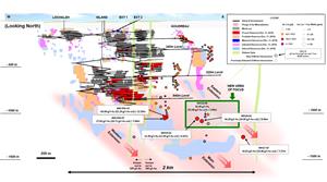
Island Gold Mine Longitudinal
Figure 2 - Island Gold Mine Longitudinal Main and Eastern Extensions - Surface Directional Drilling Results
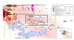
Island Gold Mine Longitudinal Main and Eastern Extensions - Surface Directional Drilling Results
Figure 3 - Island Gold Mine Longitudinal Main and Eastern Extensions - Underground Exploration Drilling Results
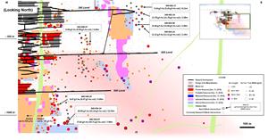
Island Gold Mine Longitudinal Main and Eastern Extensions - Underground Exploration Drilling Results
Figure 4 - Island Gold Mine Cross Section - Main and Eastern Extensions
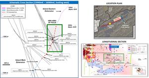
Island Gold Mine Cross Section - Main and Eastern Extensions
EIN Presswire does not exercise editorial control over third-party content provided, uploaded, published, or distributed by users of EIN Presswire. We are a distributor, not a publisher, of 3rd party content. Such content may contain the views, opinions, statements, offers, and other material of the respective users, suppliers, participants, or authors.