
The Miners' Way in the high hills
Reporter David Medcalf had the pleasure of walking a new trail across the Wicklow Mountains, where more than a century and a half of lead mining has left marks. His guide on the day was Charles O'Byrne
‘New Miner’s Way’ walking trail
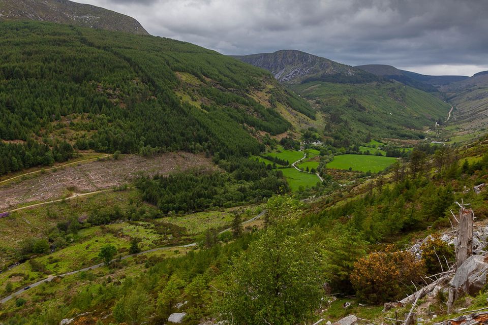
The Miners' Way It is a bold concept, but a simple enough idea, covering 19 kilometre and three valleys - Glendasan, Glendalough and Glenmalure. All three of these valleys are stunningly beautiful and all three also boast an intriguing industrial heritage.
Of course Glendalough, best known of the trio, is famed for its association with Saint Kevin and the mediaeval monks who followed in his holy footsteps. But this wild upland area also boasts a mining past which has left savage scars on the landscape for those who know where to look.
It turned out that there was little or no gold in these here hills for the prospectors of the 18th and 19th centuries. What they found instead was lead, a valuable enough commodity which attracted international investment.
The result was a series of tunnels driven into the sides these mountains along a geological line where solid granite meets crumbling schist. Hundreds of jobs were created in the hills as the ore was dug out and given preliminary treatment, though it was tough work and eventually not worth the effort.
The tunnels- known in the trade as adits- are now flooded with water or clogged with silt and strictly off limits, the last of these enterprises having closed in the 1950s. Piles of light coloured spoil mark the entrances to the abandoned adits. Tumbling stone walls of buildings long since abandoned provide reminders of the mine complexes, while rusting iron contraptions recall the process of crushing and preparing crude metal.
Now the good folk of the Pure Mile in Glenmalure and the Glens of Lead groups have teamed up to open a new trail for hikers to explore this historical territory. The Miners' Way is a strenuous six hour trek through mountainous countryside, due to be officially launched at the end of this week - on Friday, June 7.
The Way is marked by direction posts carrying a distinctive logo of a miner's pick. The paths which comprise the route all existed before they were combined in this way to make the trail, though some stretches have been given a spring clean. In places, the Miners' Way posts are shared with some of the walks which radiate out from Glendalough and a section further on doubles up with the Wicklow Way.
The project has won backing from local and national bodies as well as practical support from Coillte and the National Park service. Rather than spend whatever money was raised on path laying, the investment has gone into the signs and into the picture boards which explain the mines to walkers. And in between the industrial sites, are kilometre after kilometre of open mountain and shady woodland, as the going underfoot varies from stone steps and boardwalks to forest roads and heathery peatland.
Your reporter was privileged to be given a sneak preview of this imaginative initiative in the company of seasoned walker Charles O'Byrne from Glenmalure. Lean and quietly energetic, the 59 year old was primed and ready for an early morning start from the car park Glendasan. High above Laragh on the road to the Wicklow Gap, he checked that all gear was in order, though the day was fine.
'There's always a wind up here,' observed from our standpoint high up the valley as we stood in an arid, stony wilderness. The freshly printed leaflet which offers a map and a rundown of the history also spells it out that followers of the Way must dress appropriately. And it also stresses that there is nowhere along the 19 kilometres to stock up on food or water - so bring your own supplies is the message.
Our starting point is this wasteland of cast off stone and rock below the rounded peak of Camaderry Mountain. This was once a hive of mining activity, not so very long ago, recently enough that some of the people who worked here are still alive. Charles picked his way to the mouth of an old adit where may be found a poignant memorial to a young man who died before the plug was pulled.
The stone is engraved in memory of James Mernagh, who was just 24 years old when he was killed in an explosion in 1957, leaving a wife and two children behind. The blast in what was called the Fox Rock mine left his young comrade Robert Carter with ears ringing and an assortment of injuries.
But Robert survived the dynamite mishap and he has since made it his mission with Glens of Lead to ensure that James Mernagh and all the rest are never forgotten.
Glendasan, opened in 1807, was finally shut down by the Canadian Mining Company a few months after the fatal accident, bringing an end to lead extraction in the three valleys. It is now a desolate spot, where plants struggle to gain a foothold, where once scores of men, women and children used to labour breaking rocks.
The Way heads down a remarkable rock staircase to find level ground in the calm green of the Glendasan valley below. We peered into the forest and picked out the long overgrown stones of Fiddler's Row, accommodation for the miners. Then, just as we closed in on the coach parks and souvenir stalls of Glendalough, we took an abrupt turn instead into the trees.
Charles paid tribute to Coillte, who control much of the land through which the Miners' Way passes, with special mention of Barry Coad and Jasper Peterson. Up and over a ridge, we emerged from the forest to find the Upper Lake waiting, prompting a further thank you, this one for National Parks and Wildlife, whose Anne Fitzpatrick and Wesley Atkinson are the model of helpful enthusiasm. And while Charles was at it, there were words of gratitude too for Bryan Fennell of County Wicklow Partnership.
The road beside the lake is not a religious pilgrims' path but was originally laid as a mining company track. The scots pines, with their rusty bark, growing alongside, provided the timber considered best for propping up the mining tunnels.
The mine above the lake was first exploited in the 1850s and it is another bleak but compellingly intriguing spot. The picture board tells how the water and power of the Glenealo river was harnessed to drive the extraction of the lead ore. The highest adit was christened Van Diemen's Land by miners dismayed at how far removed it was from civilisation.
Two of the valleys three down, with only one to go, but we were still shy of half way, as we zig-zagged up to Van Diemen's Land, across the river and off in the general direction of Mullacor Mountain, spying the first deer of the day as we did so.
The footslog from Glenealo to Avonbeg valley was anything but straightforward as we marched through the fraughan bushes. Along the way we passed the highest point of our journey, on the saddle between Mullacor and Lugduff, a lofty 600 metres above the level of the distant sea. Here was the most open of open air, where we were lucky enough to witness a soaring white-tailed eagle jousting with a kite - soaring rival birds of prey contesting the glorious wide sky.
Eventually, we came back from heaven to earth, picking our way down the old donkey trail formerly used by hardy, sure-footed asses bringing baskets of turf to keep the workers in Glenmalure warm. A red squirrel skittered up a pine tree and then, after hours of near wilderness came a glimpse of glossily green field and we hit Ballinafunshoge, the first mine to be opened in Glenmalure. Lead was first exploited here in the late 18th century. At one stage, the workforce was large enough to justify opening a school for their offspring.
Finally, a tarmac road brought us to the finish line at the crusher house in Baravore to conclude a splendid six hours of exercise and exhilaration, with the hospitable warmth of the Glenmalure Lodge not too far away.
'In 2017 and 2108 we organised a walk as a Heritage Week event and we had maybe 50 people each time,' recalled Charles. A former IT worker, originally from Dublin, he moved out from the city to Glenmalure with his wife to forge a new career as walk guide escorting hiking clubs, foreign tourists and corporate parties.
He explained how the route planners stressed six major sites - two in each of the three valleys - as the Miners' Way evolved. On to the experience of former mine worker Robert Carter was grafted the engineering expertise of Dave Shepherd and the knowledge of local historian Carmel O'Toole. Now they have made the once a year walk into a fine public amenity.
Wicklow County Council sees the Miners' Way, the new Sugarloaf Way and planned Vartry Way as part of a wider vision: 'The ultimate plan is that you could step off the DART in Bray and walk all the way to Tinahely - an alternative to the Wicklow Way,' explained Charles. In the meantime his Miners' Way offers a bracing day out for anyone with a stout pair of hiking boots.
